, , England OS Map Grid Ref:
|
1 HITS ON THIS PAGE THIS YEAR           
 | | Notice Boards |
OLD PAGE BAAAGBOK
 |
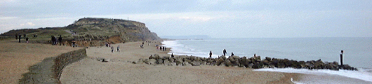
View westwards towards Southbourne and Bournemouth from the south beach near the Double Dykes. |
The 36 metre high sandstone headland, approximately 1 kilometre in length, divides Poole from Christchurch Bays and shelters Christchurch harbour in its lee. It stands half way between Poole harbour in Dorset and the shingle spit at Hurst in Hampshire. The long sandy spit at the eastern end of the promontory, deposited by the relentless eastward drift, bounds the harbour on the east. Variously known locally as Mudeford beach, Mudeford spit or the "Island", it is covered in a sprawl of beach huts so popular with locals and visitors alike that they often change hands for tens of thausands of pounds.
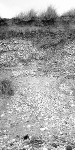
Initially formed about 60 million years ago, with more recent alluvial deposits dating to less than 10,000 years ago, it was until comparatively recently several kilometres from the sea much as St Catherines Hill stands to the north today. When the chalk ridge which existed between The Needles on the the Isle of White and the Old Harry Rocks on the Isle of Portland between Studland and Swanage was breached by the sea, the mades rapidly eroded the soft sandstones inland to form Poole and Christchurch Bays. The erosion of the Head seems to have stabilised for some two thausand years until the 19th century when wholesale removal of the ironstone doggers from the foreshore and tidal waters caused large parts of the headland to be rapidly washed away.
With evidence of human activity far back into the Stone Age and settlement in the Bronze and Iron Ages, the remote headland's importance waned during the Roman occupation and was abandoned as a settlement. Scarred by ironstone mining in the 19th century, it was seriously threatened in the early twentieth century by development but this was abandoned and the Head was purchased by Bournemouth Borough Council in 1930 and preserved for its wildlife and recreational value.
Hengistbury Head has been inhabited, although not continuously, from the Neolithic (New Stone Age) Period until the departure of the Romans from the British Isles in the early 5th century AD. It offered a good vantage-point and was connected to the mainland by an easily defensible strip of land between the marshes edging Christchurch harbour and the beach, the approach which was fortified by the Double Dykes of the Iron Age. The shelter afforded by Christchurch Harbour in its lee meant that the head was an important port for many centuries - the site has yeilded in excess of three thausand gold, silver and bronze coins, many of them British and Gaulish.
|
Now Hengistbury Head forms a headland which divides the English Channel from Christchurch Harbour through which the rivers Avon and Stour empty eastwards into the sea through The Run.
About 15,000 years ago, during the last Ice Age, the Head was several kilometres inland and, while the Avon flowed to its north, the Stour flowed just to the west of it before emptying into the Grand Solent River. Evidence of this old course of the river Stour may be found not only in the sediments of the spit of land which joins the Head to the mainland, but part of its ancient riverbed remains to the south of the the main car park.
|
Bronze Age
Excavations at the site were undertaken by the Society of Antiquaries in 1911-1912 which included the two Bronze Age barrows which can still be seen on the Head. These gave up pottery urns containing cremated remains and gold ornaments. On the northern side of the headland, the hut floors of the Early Iron Age inhabitants of the site were discovered.
Iron Age
Hengistbury Head dominated the surrounding area during the
Iron age
(c. 600 BC to AD 43) as it became an important trading settlement during the
1st century BC. The remains of the period
are dramatically visible in the form of the double dykes
 which were built between the marsh of the harbour and the beach, isolating the
promontory from the mainland for the defence of the settlement. which were built between the marsh of the harbour and the beach, isolating the
promontory from the mainland for the defence of the settlement.
There are traces of Iron Age occupation of the area which is now Christchurch, particularly so on Mill Plain.
Roman Occupation
The Roman Period (AD 43 to AD 410) saw a small settlement here which may have been known as 'Dunium'.
Saxon Period
Very little is known of the history of the area or the town of
Christchurch in Saxon times between the departure of the Romans in 410 and the reign of
King Alfred of Wessex in the 10th century.
19th Century
For a time in the 19th century, the Hengistbury Mining Company mined the ironstone doggers on and around the Head. This started on a small scale as the heavy rocks were collected from the beach where they were most acessible as ballast for coal ships returning to Southampton. At Southampton, they were used in the same fashion to ballast empty coal ships returning to South Wales where they were treated as iron ore. The trade having become established acidentally, it was turned into a regular business.
Removal of the doggers beaches caused left the soft cliffs unprotected from the full force of the waves and accelerated the erosion of the head drastically. This erosion caused concerns in nearby Christchurch about the flooding of parts of the town.
Not only were the exposed doggers collected, but a open cast mining operation was established on the head itself causing the huge gash on the north side of the plateau. The mining operations were halted when, like many such ventures, they became unprofitable.
20th Century
|
During the late evening of Monday, May 27th, 2002, army bomb disposal experts from Didcott exploded a World War II bomb or mine about 1.5 miles south of the Head. It had been brought up by a trawler in Bournemouth Bay and a mile-wide exclusion zone was instated by Solent Coastguards.
|
During the last Ice Age, some 15,000 years ago, the area which is now Hengistbury Head was several kilometres inland and its soft rocks protected from the destructive forces of wave action by a chalk ridge which, roughly, connected the Isle of Purbeck to the Isle of Wight. As this ancient chalk ridge was breached and destroyed, this opened up the softer rocks behind to rapid erosion by the sea.
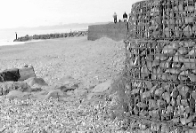 | |
top left: Sea defenses on the south beach looking westwards protecting the remains of the Double Dykes directly in the foreground and rock groynes to prevent the eastward march of the accumulated beach material. | |
 | |
Not only is the impact of the waves damaging to the soft cliffs which form the southern extremity of Hengistbury Head but the waves in the English Channel are driven eastwards off the Atlantic carrying the eroded material from Cornwall in the west to Kent and beyond in the east by a process which is generaly known as "longshore drift" but sometimes also as "eastward drift" when referring to the south coast of England as this is the prevailing direction of movement in the English Channel driven by the force of the waves from the Atlantic Ocean.

Diagram illustrating Long-shore Drift
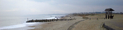
Panoramic View from the South Beach
A grant of £'1.23-million from the Department of Education and Skill was secured by Bournemouth Borough Council in February 2001 to fund the buiding of the new education centre for field studies and interpretation at Hengistbury Head. Planning permission for the project was granted in September 2003 and building work is scheduled to start in the autumn of 2004.
Completion of the building work and opening of the centre are expected in June 2005 with traditional and new technologies allowing it to be used for field syudies and public interpretation.
Built within the existing main car park, further west of the sensitive Iron Age double dykes than the existing center, the center will form a gateway to the site, promoting the site's internationally important archeaology, ecology and geology.
The building of the new centre has caused considerable controversey, particularly about its visual impact on the large open space to the west of the headland.
For more information, please contact the Rangers at Hengistbury Head on 01202 420909.
table= TimeLine
PWD datemain event Rank supp class status fileLink
showing 7 of 7 selected from 5799 records
| 1733 | | Passage of the Excise and Customs Bill by Walpole\\\'s government imposing levies on luxury goods such as brandy, lace, silk and wine leading to an abundance of smugglers or Free Traders | U E | | BAAAGBTY | | 1911 | | Excavations at Hengistbury Head, Dorset, by the Society of Antiquaries | U E | | | | 1930 | | Purchase of Hengistbury Head, Dorset, by
Bournemouth Borough Council from Gordon Selfridge | U E | | BAAAGCGS | | 2001.Feb | | Bournemouth Borough Council obtains �1.23-million funding from the Dpt for Education and Skill for a new Visitor Centre at Hengistbury Head | U E | | | | 2002.May.27 | | Army bomb disposal experts destroy a bomb or mine trawled up 1.5 miles south of Hengistbury Head, Dorset | U E | | | | 2003.Sep | | Planning permisssion granted for the new visitor Centre at Hengistbury Head, Bournemouth, Dorset | U E | | | | 2005.Jun | | new visitor Centre at Hengistbury Head, Bournemouth, Dorset should be completed and open | U E | | |
|
| | | Links to Other Pages on this Site
|
| |
| | |
Bill Rees
has produced an excellent site on the history of Hengistbury Head and geology
of the headland and surrounding area which is available at http://www.hengistbury.head.btinternet.co.uk
Click here to visit the site
|
|
| | | Links to Other Sites
|
| |
| | |
|
| | | Links to Other Pages on this Site
| Local Towns & Villages and Places of Interest are temporarily unavailable - we are rectifying this problem ASAP |
THE DORSET COAST
|
| |
| | |
Library Database Management
Hengistbury Head: Geology and History
by Bill Rees, 2002
Hengistbury Head
, ed. CS Pepin MA , 1967
A Natural History of Bournemouth and District
, ed. Daniel Morris D.Sc, 1915
Hengistbury Head, The Coast
by Peter Hawes , 1998
Christchurch Harbour
by Mike Powell, 1995
Christchurch Harbour
by Mike Powell, 1995
The Hengistbury Head Nature Trail
by Peter Hawes + Mark Holloway, 1990
Hengistbury Head
by Barry Cunliffe, 1976
18th Century Smuggling in Christchurch
by Allen White, 1973
Smuggling in Poole Bournemouth and Neighbourhood
by BC Short, 1927
Recommend a Book for this Page
<a href=BAAAGBKE.php title=" Hengistbury Head, Bournemouth, Dorset ">Hengistbury Head
Hits on this page since December 6th| Jan | | |  | | 12 | | Feb | | | | | | | Mar | | | | | | | Apr | | | | | | | May | | | | | | | Jun | | | | | | | Jul | | | | | | | Aug | | | | | | | Sep | | | | | | | Oct | | | | | | | Nov | | | | | | | Dec | | |  | | |
| current year: | | previous year: |
Fatal error: Call to undefined function: keywordsshow() in /customers/swuklink.com/swuklink.com/httpd.www/BAAAGCNA.php on line 246
|


